logo.png
Goechala Trek
Adventures Events Eat & Drink Party & Drink Travel
Home / Experiences / Adventure / Trekking / Goechala Trek

Goechala Trek

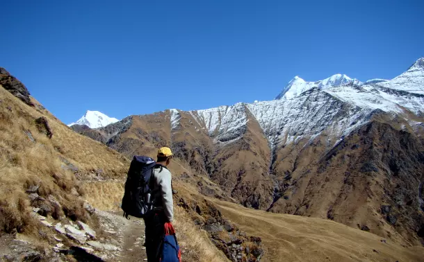
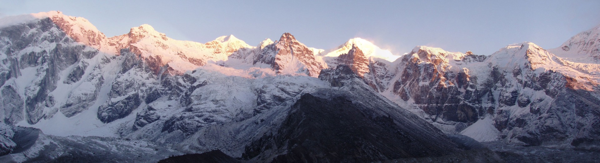
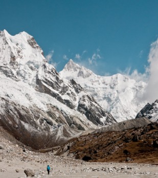
For those who love a grand and majestic view on their trek, then Goecha La is the perfect trek spot for you. With a panoramic view of the world’s most beautiful and largest mountain, Mt Kanchenjunga. Goecha La earned the popularity among trekkers rapidly and overnight. It was because of the Nepalese Civil War (1996-2006) that the place was shut for trekkers and people were desperately seeking other alternatives for the one. Goecha La is a high mountain pass in Gyalshing district, Sikkim, India in the Himalaya range. The southeast face of Kanchenjunga, the world's third highest mountain, can be viewed from the pass, which is also a base camp for those aspiring to scale the mountain.

Important Information on Goechala Trek

Difficulty Level

The Goecha La is a high-altitude trek which takes you beyond 15,000 feet. The trek climbs rapidly, and is however long and strenuous. Having a prior experience helps in over coming the difficulties in the Himalayas. You may experience Acute Morning Sickness (AMS) on your climb, so it advised to do a little research and have a knowledge about it in order to avoid it on your trek. An acclimatization day is suggested in Dzongri as it will greatly increase your safety on the Goecha La Trek.

Altitude to Cover

  • Sachen – 5,840 to 7,400 feet
  • Tshoka – 7,400 to 9,790 feet
  • Dzongri – 9,790 to 13,190 feet

Weather Conditions

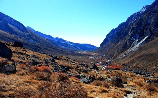
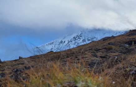
Since the Goecha La Trek has an altitude of more than 15,000 feet, a spell of rain on lower slopes can lead to light or heavy snowfall anytime on the climb. It is highly possible that the rainfall or snowfall could last for more than four hours, if so happens, the trail could be flooded or could be too slushy, making it unsafe to walk on. The clear possibility of snowfall in Goecha La is in near Dzongri. These could obstruct the previous made paths and would indicate that fresh tracks have to be cut out of the snow.

Trek companies

There are several trekking sites that offers trek to Goecha La. Some of them are listed below:

  • IndiaHikes – INR 16,550 *per person (www.indiahikes.com)
  • The Trek Himalayas – INR 16,650 *per person (www.thetrekhimalayas.com)
  • Bikat Adventures – INR 18,900 *per person (www.bikatadventures.com)
  • Thrillophilia – INR 15,950 *per person (www.thrillophilia.com)
  • Trek In Sikkim – INR 15,000 *per person (www.trekinsikkim.com)
Things to Keep

Before you undertake a trek in Goecha La, make sure you have all the necessary items packed in your backpack. Also,it is mandatory for you to carry your documents along with you.

Documents to carry –

Indians-

  • Original and 3 photocopies of government photo identity card
  • 3 passport size photos
  • Original and 3 photocopies of Medical Certificate
  • Original and 3 photocopies of Disclaimer form.

Foreigners-

  • Original and 4 copies of Inner Line Permit (ILP)
  • 4 passport size photos
  • Original and 4 copies of Passport
  • Visa in Original and 4 copies
  • Original and 4 photocopies of Medical Certificate (first part to be filled by a doctor and second part by the trekker)
  • Original and 4 photocopies of Disclaimer form (to be filled by the trekker)
  • Trekking shoes with ankle support
  • Backpack with rain cover
  • 3-4 layers of warm clothing (depending on the season you are undertaking the trek in)
  • Sunglasses, Sun cap with flaps, Waterproof gloves
  • Balaclava
  • Woollen socks (3 pairs)
  • Headlamp
  • Trekking pole
  • Rain jacket + pants / poncho
  • Toiletries – Sunscreen, Moisturizer, Light towel, Lip balm or Vaseline, Toilet paper, Toothbrush, Toothpaste, Reusable plastic covers (for used clothes)
  • Cutlery – Steel lunch box, spoon and mug, two water bottles or Hydration Pack
Information for foreigners on Goecha Trek

Foreigners (Non-Indian passport holders) must reach Yuksom, the base camp, a day prior the reporting day. It is required to obtain the foreigner trek permit from Gangtok. This is required by the Government of Sikkim. The permit costs around Rs. 2,000.

Goechala Trek Itinerary

  • Day 1- On the first day, you will be driven from 2-mile check post to Yuksom. The trek starts from Yuksom, a large settlement in West Sikkim. The place was once the capital of Sikkim. There are two important things primarily which you are required to do once you reach Yuksom, first you need to make an entry at the police station and for this purpose you will require your photo identity proof and three photocopies of it, and second, you are required to pay the permit fees at the forest check post.
  • Day 2 - The trek from Yuksom to Sachen begins.The trail passing through the fringes of the forest is exposed for about half an hour. From here onwards it is half-hour to the first bridge over the Pha Khola. The next half hour is a pleasant walk through the moist jungle until suddenly on your left the Tshushay Khola falls in a series of mini-waterfalls joining the Prek Chu river below. You are already at 7,100 feet and it is only twenty minutes from here to the log hut of Sachen, it is at 7,400 feet and is a small clearing where a single log hut and a shelter on the trail exist. The log hut is a few meters below the trail.
  • Day 3 - A 5.5 hours trek fromSachen to Tshoka via Bakhim. From Sachen, the trail climbs sharply through a mixed oak forest. The altitude gain is rapid and the temperature decreases rampantly. Bakhim has a forest Rest House which provides a view of the Yuksom Valley.
  • Day 4 - The fourth day of the trek marks the trek from Tshoka to Dzongri via Phedang. Phedang is at 13,000 feet which is a large clearing that provides an amazing view of the snow-clad mountains.
  • Day 5 - Acclimatization Day at Dzongri. The trek starts with a climb to Dzongri. Dzongri Top at 13,670 ft, is the highest point from where you get 180-degree panoramic view of the mighty peaks of the Singalila and Kanchenjunga ranges such as Kakthong, Rothang, Kabru South, Kabru North, Kabru Dome, Kanchenjunga range, Pandim, and the Lama Lamini peaks. Later, retrace your path from Top of Dzongri to Dzongri which takes around 30 minutes.
  • Day 6 - Trek from Dzongri to Thansing via Kokchurang. The duration of the trek is approximately 6 hours and the altitude gained or lost is 13,190 ft to 12,910 ft via 12,090 ft.
  • Day 7 - Trek from Thansing to View Point 1 via Samiti Lake; and back to Thansing. The duration of the trek is 12-14 hours. This is the longest day of the trek and so start your day early at midnight to give you multiple advantages such as, it ensures that you reach the first viewpoint or the sunrise point right in time to see the first sun rays hitting Kanchenjunga; It also makes it easier to walk on the moraines that you find after the sunrise point as the snow is still hard.
  • Day 8 - From Phedang you retrace the descending trail to Tshoka. The day's trek takes about 8-9 hours on average.
  • Day 9 - Retrace your way from Tshoka to Yuksom. It's much faster and easier than your trek up. Sachen comes up quickly being a pure descent.The last stretch has a few climbs which make you wonder but it's soon over and you find yourself back in the friendly Yuksom neighbourhood.

Best Time to do Goecha Trek

The best times to visit Goecha La are in Spring – from end of March to middle of April and in Autumn – from September end to start of November.

Frequently Asked Questions(FAQ)

Where is Goecha La?

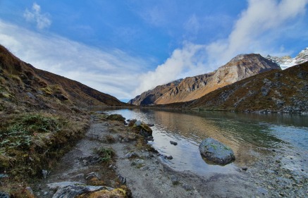
Goecha La is a mountain pass at an altitude of 16,207 feet in West Sikkim. It is 60 km away from Jorethang which lies on the border of West Bengal and Sikkim.

How long is Goecha La trek?

The Goecha La is 65.7 km long from Yuksom. You gain approximately 10,000 feet in while covering the distance. During the trek you also get to witness Mt. Kanchenjunga, the third highest mountain in the world, when you reach an altitude of 15,000 feet.

What is the best time to visit Goecha La?

Spring and Autumn are considered to be the beast seasons to undertake a trek in Goecha La. The Spring is marked by oak forests and rhododendrons, while Autumn witnesses’ brilliant blue autumn sky.

Copyright 2012-2024 Indiamap Digital Private Limited. All rights reserved. Privacy Policy | Terms of Use